Enuiry Form for Property Searching
https://forms.gle/VzYALH7ktjHPJh147
Hyderabad Regional Ring Road – Information & Status
340 km Hyderabad Regional Ring Road (RRR) expressway project by NHAI is a proposed 4 lane access-controlled road connecting the towns of Sangareddy, Toopran, Choutuppal, Amangal, and Shankarpally.
Hyderabad Regional Ring Road (RRR), a significant infrastructure project in Telangana, India.
Overview
The Hyderabad RRR is a proposed expressway encircling the city of Hyderabad. Here are the key points:
- Length: The RRR spans approximately 340 kilometers.
- Purpose: It aims to enhance regional connectivity, ease traffic congestion, and foster economic development.
- Alignment: The RRR runs roughly 30 kilometers away from the operational 158-kilometer Outer Ring Road (ORR).
- Towns Connected: The expressway will link several towns, including Sangareddy, Toopran, Choutuppal, Amangal, and Shankarpally
Project Details
- Phases: The RRR will be developed in two portions:
- Northern Half: Approximately 164 kilometers, estimated to cost Rs. 9,500 crore. It will connect towns like Sangareddy, Narsapur, Toopran, Gajwel, Yadadri, Pragnapur, Bhongir, and Choutuppal.
- Southern Half: Approximately 182 kilometers, estimated to cost Rs. 6,480 crore. It will connect Choutuppal, Ibrahimpatnam, Kandukur, Amangal, Chevella, Shankarpally, and Sangareddy.
- Ownership: The project falls under the National Highways Authority of India (NHAI).
- Design: Initially, it will be an access-controlled four-lane expressway, but further details will depend on the Detailed Project Report (DPR) recommendations.
- Status: As of now, the DPR for the northern portion is under preparation1.
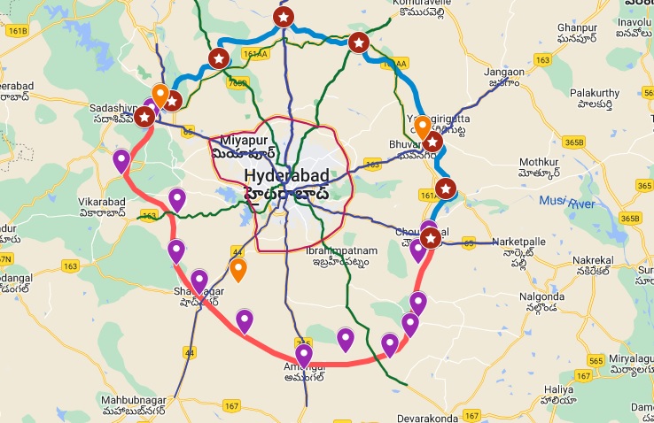
Route Map
The RRR will intersect various national highways (NH-44, NH-164, NH-65, NH-765, NH-63) and state highways (SH-1, SH-19). While the official PDF route map is yet to be finalized, the indicative alignment is available
This new greenfield expressway in Telangana will be developed in 2 parts (northern & southern) under the government’s Bharatmala Pariyojana (BMP) Phase-I program. Telangana Government plans to bear 50% of its land acquisition cost and allocated Rs. 750 crore towards it in its 2021-2022 budget.
- Total Estimated Cost: Rs. 17,000 crore
- Project’s Total Length: 340 km
- Lanes: 4
- Status: DPR Preparation
- Deadline: Not Announced
- Owner: National Highways Authority of India (NHAI)
- Project Model: Not Announced
The project will be developed in two portions:
Northern half with a length of approx. 164 km is estimated to cost Rs. 9,500-crore and will connect Sangareddy, Narsapur, Toopran, Gajwel, Yadadri, Pragnapur, Bhongir and Choutuppal.
Southern half with a length of approx. 182 km is estimated to cost Rs. 6,480-crore and will connect Choutuppal, Ibrahimpatnam, Kandukur, Amangal, Chevella, Shankarpally and Sangareddy.
Route Map
Hyderabad Regional Ring Road’s alignment will run roughly 30 km away from the operational 158 km Outer Ring Road (ORR). It will connect various national highways and state highways such as NH-44, NH-164, NH-65, NH-765, NH-63, SH-1, and SH-19.
Enuiry Form for Property Searching
https://forms.gle/VzYALH7ktjHPJh147
Enuiry Form for Property Searching
https://forms.gle/VzYALH7ktjHPJh147
Introduction: Regional Ring Road, Hyderabad
Background and Overview
The Regional Ring Road (RRR) is a proposed 340-kilometer, six-lane expressway designed to encircle Hyderabad, Telangana. Positioned approximately 50 kilometers from the existing Outer Ring Road (ORR), this project is a key initiative under Bharatmala Pariyojana Phase-2, with an estimated cost of Rs 26,000 crore. The primary objective of the RRR is to enhance connectivity, alleviate traffic congestion in central Hyderabad, and promote infrastructure growth across suburban and rural areas.
This access-controlled highway will link key locations, including Sangareddy, Narsapur, Toopran, Gajwel, Jagdevpur, and Choutuppal. By providing an alternative route for vehicles that do not need to enter the city, the RRR will significantly improve traffic flow and facilitate regional economic development. The state government has already initiated land acquisition in a phased manner to expedite construction.
Significance in Hyderabad’s Real Estate Market
The RRR will traverse 125 villages and intersect three major state highways, making it a catalyst for real estate growth in Hyderabad and its peripheries. The Hyderabad Metropolitan Development Authority (HMDA) has integrated this project into its master plan, aiming to enhance the road network and extend urban development beyond the ORR.
As new townships and commercial hubs emerge along the RRR corridor, demand for residential and commercial properties is expected to rise, particularly in districts adjacent to Hyderabad. The state government has allocated over 9,000 acres for the project, marking it as one of the largest road infrastructure initiatives in the country.
Route and Connectivity
Proposed Route and Key Junctions
The RRR is divided into two sections: the northern and southern halves. It will connect 20 towns and 40% of Telangana’s population to the national and state highway network. The route spans multiple districts, integrating NH-44, NH-164, NH-65, NH-765, NH-63, SH-1, and SH-19.
Northern Half (164 km):
- Sangareddy Junction
- Doulthabad
- Narsapur Junction
- Toopran Junction
- Gajwel Junction
- Jagdevpur
- M. Turkapally
- Bhuvanagiri Junction
- Valigonda
Southern Half (182 km):
- Choutuppal Junction
- Marrigudem
- Amangal Junction
- Keshampet
- Shadnagar Junction
- Chevalla Junction
- Nawabpet
Status of the Northern and Southern Sections
The northern segment, spanning 158.4 km, has received National Highways Authority of India (NHAI) approval. Land acquisition is underway, with the Telangana government covering 50% of the costs. Meanwhile, the southern stretch (182 km) has also received central government approval, with utility relocation expenses being covered by the Union Ministry of Road Transport and Highways.
Impact on Infrastructure and Transportation
The RRR is set to revolutionize Hyderabad’s transportation framework by integrating road, rail, and other transit systems. It will intersect existing highways, five reserve forest areas, and seven infrastructure projects, ensuring seamless connectivity across the region. The road will also include interconnectors to the ORR, improving traffic flow and reducing travel time.
However, delays due to resurveying and funding constraints have raised concerns regarding the project timeline. The completion of the RRR is crucial to enhancing regional connectivity and mitigating congestion within Hyderabad.
Government Initiatives and Investment
The Telangana government, in collaboration with the central government, has prioritized the RRR project under HMDA’s Master Plan 2031. Land acquisition for 1,785.5 acres has begun, with an equal cost-sharing model between state and central authorities. The overall construction costs will be borne by the central government.
The RRR is expected to stimulate economic activity, generate employment, and support urban expansion. With a planned investment of Rs 26,000 crore over five years, the project is anticipated to propel Hyderabad’s real estate sector forward by two to three decades.
Real Estate Development and Market Trends
Investment Potential and Property Price Impact
The RRR’s construction is expected to drive real estate demand, leading to property price appreciation in connected localities. Estimates suggest a 40%-50% increase in property values along the RRR corridor. Areas such as Shadnagar, Maheshwaram, and Shankarpally have already witnessed a surge in land prices due to anticipated infrastructural growth.
Despite budgetary concerns and project delays, market trends indicate strong investor interest. The average property price outside Hyderabad increased by 120% during the pandemic, reaching Rs 2,694 per sq. ft. by the end of 2022. The ongoing development of new townships and industrial zones along the RRR is expected to sustain this upward trend.
Current and Proposed Real Estate Developments
Developers are actively planning residential and commercial projects around the RRR. HMDA has proposed connecting the ORR and RRR with over 50 radial roads, promoting satellite townships in regions like Ibrahimpatnam and Shankarpally. The demand for plotted developments, gated communities, and industrial hubs is projected to rise significantly.
Environmental Considerations
Ecological Impact and Mitigation Measures
The RRR’s construction, requiring over 9,000 acres of land, has raised environmental concerns, particularly regarding deforestation and habitat disruption. The government has outlined measures to minimize ecological damage, including:
- Sustainable Construction Practices: Using eco-friendly materials and techniques to reduce waste.
- Wildlife Preservation: Avoiding construction in ecologically sensitive zones.
- Green Belt Development: Implementing afforestation initiatives along the highway to offset environmental impact.
In conclusion, while the RRR is poised to transform Hyderabad’s infrastructure and real estate landscape, timely execution and sustainable development strategies will be critical to maximizing its benefits.